Storm Arwen brings amber warning of windy weather to Scarborough and the Yorkshire Coast


The amber warning will run from 15:00 on Friday to 09:00 on Saturday, with the strongest winds expected in coastal locations, where gusts in excess of 75mph are possible in some places.
As well as high winds and disruptive gales, Storm Arwen will bring snow to the high ground of Scotland and northern England and a yellow snow warning is in force for part of Scotland on Friday. Some sleet and snow is also possible over some lower ground in the UK later on Friday and Saturday, but this is likely to be more short-lived.
Advertisement
Hide AdAdvertisement
Hide AdStorm Arwen, a name selected as part of the Name Our Storms collaboration with Irish forecasters Met Éireann and Dutch forecasters KNMI, is set to track slowly southwards across the North Sea on Friday, bringing severe gales to the northeast in particular, but potentially disruptive winds for much of the UK.
Met Office Principal Meteorologist Dan Suri said, “Storm Arwen is associated with a deep low pressure system that will impact the northeast in particular from Friday, but will also bring wider impacts to the UK with high winds, rain and some snow probable over the high ground.
“Storm Arwen’s impacts are mainly associated with high winds as the storm sinks southwards and will widely bring gusts of up to 65mph in coastal areas, although slightly stronger in the northeast, with in excess of 75mph possible in exposed locations.”
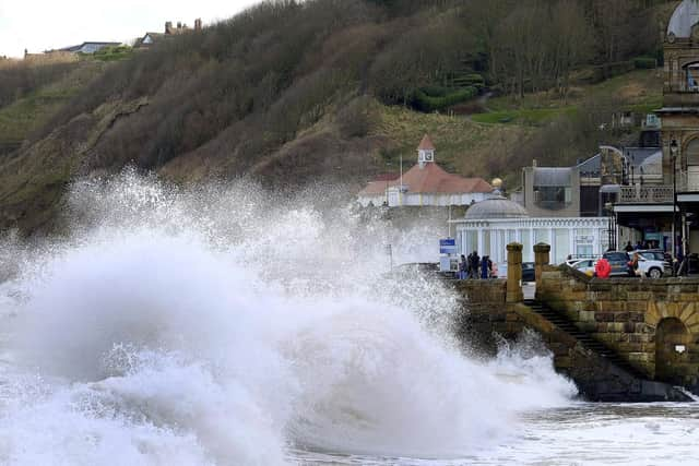
Storm Arwen brings with it the risk of disruption to travel, power cuts and potential damage, especially within the amber area and near the coasts, where large waves could see material thrown on to coastal roads, sea fronts and properties.
Advertisement
Hide AdAdvertisement
Hide AdFollowing a track across the North Sea, Storm Arwen is expected to shift away into the continent later on Saturday, leaving a drier day for many on Sunday, barring some lingering showers over the eastern coasts of England and Scotland.
The full warning reads:
High winds associated with Storm Arwen are expected to cause some travel disruption and damage.
What to expect
- Flying debris is likely and could lead to Injuries or danger to life
- Probably damage to trees, temporary structures and buildings, such as tiles blown from roofs
Advertisement
Hide AdAdvertisement
Hide Ad- Longer journey times and cancellations likely, as road, rail, air and ferry services may be affected
- Some roads and bridges likely to close
- There is a good chance that power cuts may occur, with the potential to affect other services, such as mobile phone coverage
- Injuries and danger to life is likely from large waves and beach material being thrown onto coastal roads, sea fronts and properties
Forecast
The weather forecast for the coming days says it is likely to be largely fine today with rain and strong winds overnight.
Today:
Advertisement
Hide AdAdvertisement
Hide AdThursday will feel cold with brisk northwesterly winds. It will be rather cloudy across eastern parts, with scattered showers, however the west of the region will stay largely dry with sunny spells. Maximum temperature 6 °C.
Tonight:
A dry and largely clear evening. However, shortly after midnight, cloud, strong winds and outbreaks of rain will spread in from the northwest. Minimum temperature 0 °C.
Friday:
Rain and strong winds clearing to blustery showers, heavy at times. Showers are likely to become increasingly wintry over higher ground, and perhaps down to lowers levels at times. Maximum temperature 7 °C.
Outlook for Saturday to Monday:
Very windy and cold Saturday with showery outbreaks, wintry away from the coast. Brighter and less windy Sunday as showers fade away. Milder Monday with cloud and rain spreading east.